Circa 1182
Manor Farm and the lost abbey of Brockley
By Brockley Society
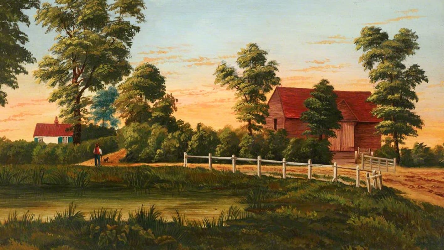
Brockley Road in 1838, when fields still surrounded the old manor lands
Stand at the meeting point of Wickham Road, Ashby Road and Breakspears Road and it takes some effort to imagine what once lay there. Traffic moves through a tight suburban junction. Terraces and villas press in on every side. Yet this was once the heart of Manor Farm, the working core of the medieval manor of Brockley.
Before the suburb, before the railway, before even the farm buildings that nineteenth century residents remembered, there was a religious house here, small, ambitious and short lived.
A manor and a monastic experiment
In the later twelfth century, probably in the 1180s, Brockley had emerged as a distinct manor within the wider estate of Lewisham. Countess Juliana de Vere granted land here to a group of Premonstratensian canons, colonists from Sulby Abbey in Northamptonshire. These White Canons, part of a reforming order founded in northern France, established a house known in charters as St Mary of Brockley.[8][9][10]
The experiment did not last long.
Within a generation the community had moved away, seeking a more suitable site on the Kent–Sussex border. There the Brockley house was transferred to a new foundation at Bayham, which developed into Bayham Abbey, whose roofless walls still stand above the River Teise.[8][11]
Brockley was left behind. Whatever church, cloister or domestic buildings had risen on its soil were abandoned or adapted. The estate reverted to lay control and passed through families including the Cutlers, Boulters, Wickhams and Drakes.[1][4][9] The memory of the canons survived only in documents and, perhaps, in foundations beneath the grass.
The lord's own farm
For centuries the land that had supported a monastery was worked instead as a farm. Manor Farm occupied the demesne — the portion of the manor retained for the lord's own use. Its fields stretched across what are now ordered streets, once open ground sloping gently across the valley.[1]
The Ordnance Survey skeleton plan of 1848–51 shows a holding of more than eighty acres arranged around a compact yard of buildings on the east side of Wickham Road, near the later line of Ashby Road. This was no ornamental estate. It was productive land, enclosed and managed with care.[1][6][13] A useful landmark for the site today is Chester Lodge, 25½ Wickham Road, a modest mid-Victorian building whose compact proportions set it apart from the larger Chester House with which it shares a driveway. The farm buildings once stood on the land directly behind it. Ashby Mews, the narrow lane running behind Chester Lodge, cuts through what was once the farmyard; roughly halfway along it is where the heart of Manor Farm would have been.
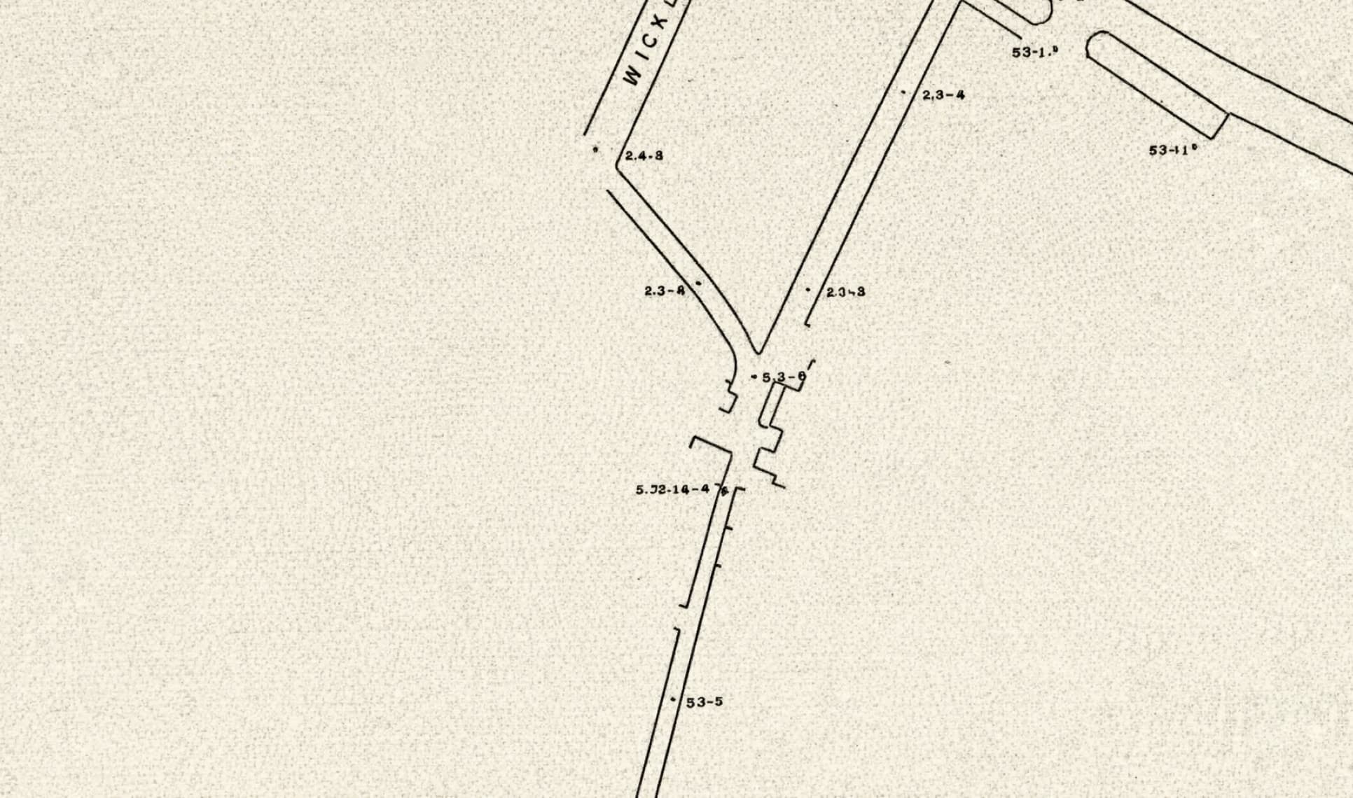
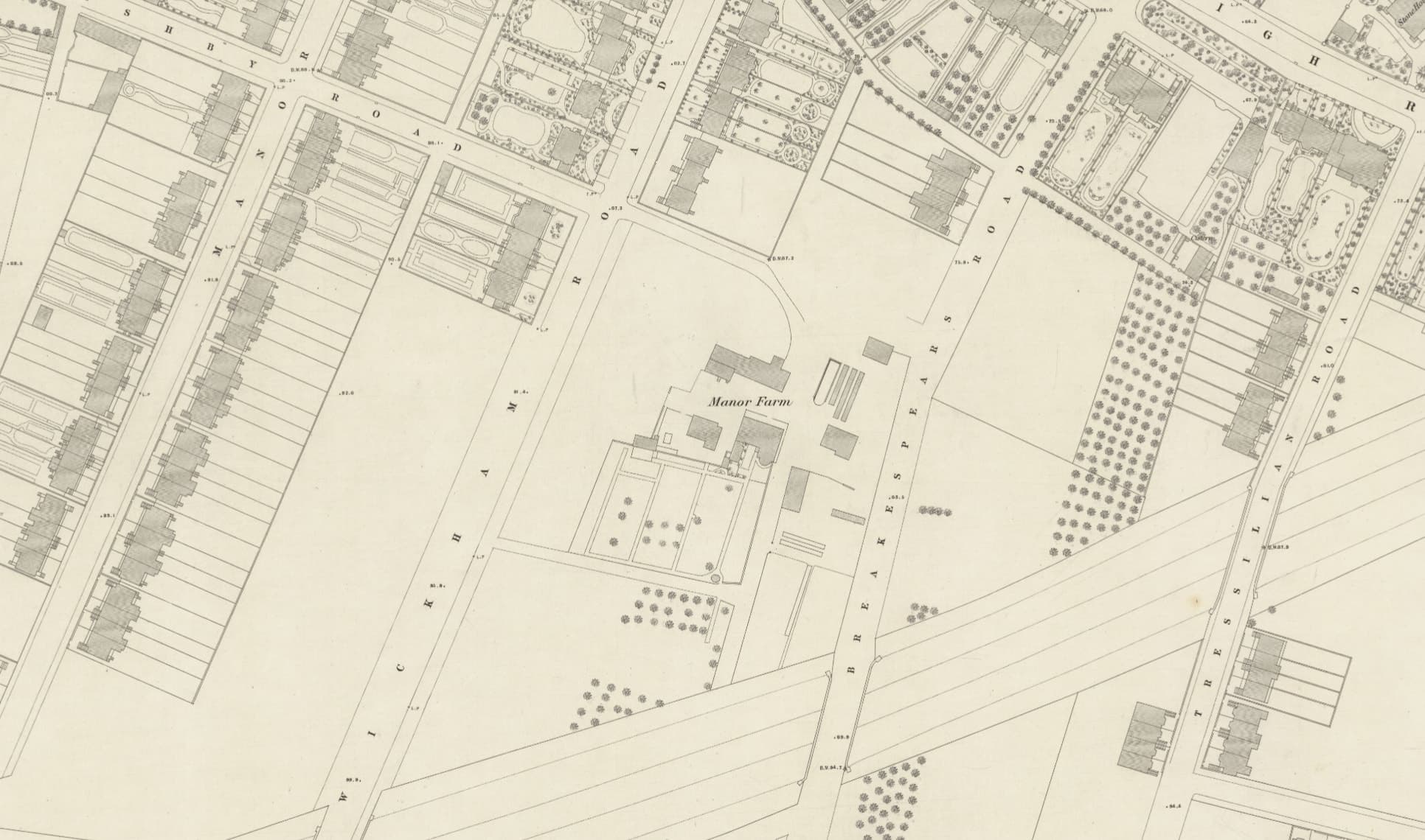
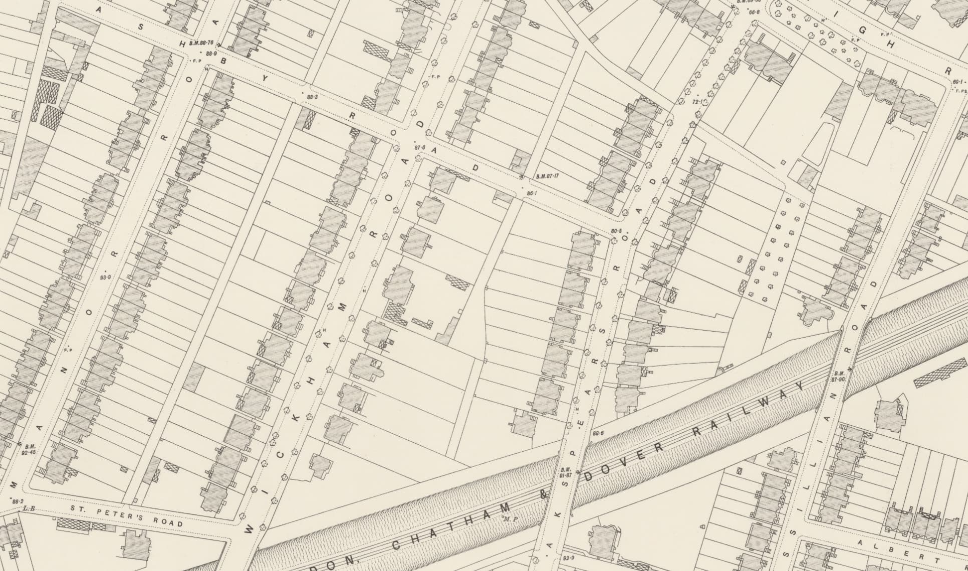
The contrast between the three maps is stark. In 1851 and 1868 the farm buildings and their surrounding fields are clearly visible. By 1896 the farmyard has vanished entirely, its land carved into building plots and new terraced streets laid across the former fields.[3][13]
By the early nineteenth century the farm was in the hands of Joseph Myatt, one of the most successful market gardeners in south London. From these fields he sent fruit and vegetables to the capital's markets. Strawberries were his speciality. In the 1830s and 1840s he bred new varieties, among them the celebrated British Queen, introduced in 1841 and widely grown in Victorian gardens.[1][5][12]
Under Myatt the former monastic lands were turned to intensely practical use. The canons had once prayed and dined here. Now rows of fruit canes and beds of rhubarb filled the same ground.[12]
Digging into the past
The medieval house might have slipped entirely from memory were it not for a grassy mound in one of Manor Farm’s fields.
In the 1860s that mound was opened. The excavation, carried out in the grounds then worked by Myatt, revealed the foundations of a rectangular building aligned on the cardinal points. Antiquarian observers identified it as the abbey refectory. The structure measured roughly thirty four by twenty one feet, with a recessed bay at one end and a narrow entrance on the long side. Large red tiles formed its floor.[1][2]
Fragments of white glazed tile, pieces of leaded window glass and a scatter of coins came to light. The coins ranged from the reign of Edward IV to that of Charles I, hinting at later disturbance or reuse long after the canons had departed.[2]
The interpretation was cautious even then. The identification as a refectory rested on form and alignment rather than inscription. Yet the discovery confirmed that substantial masonry had once stood here.[2]
When the foundations for St Peter’s Church were dug in 1870, workmen reported uncovering a deep well nearby, thought by some to be another survival from the monastic phase. An Ordnance Survey map of the 1870s marked the adjoining field as the site of a monastic building, fixing the association in print and reinforcing the traditional identification of this area as the site of the original Premonstratensian house at Brockley.[1][2][3]
Fields to streets
The change from rural manor to suburb gathered pace in the nineteenth century. The Croydon Canal opened in 1809 and closed in 1836. In 1839 the London and Croydon Railway cut through the landscape, binding it more tightly to the expanding metropolis.[1]
Speculative builders followed. Leases were granted. Plots were laid out. The fields of Manor Farm were measured, divided and built upon.[1][4]
By the end of the century the farm buildings had gone. St Peter’s stood where crops had grown. Wickham Road, Breakspears Road and Ashby Road framed a residential junction on ground that had once formed the working yard of the manor.[1][3][4]
Local historians still wrote of the abbey beneath the soil and of the farm that had succeeded it. On the surface, however, little remained. Manor Avenue and nearby addresses now occupy what was once Myatt’s garden ground. The alignment of streets faintly echoes former boundaries.[1][4][7]
Nothing of the abbey walls is visible. No trace of the farmyard survives. Yet beneath pavements and gardens lies a layered history: woodland clearing, monastic precinct, demesne farm, market garden and finally suburb.
At a quiet moment in the traffic at Wickham Road, the outline can still be imagined.
Sources
- 1.^
Spurgeon, Darrell, A History of Brockley, serialised on Brockley Central, 2013 — Source archive
- 2.^
Heritage Gateway, Brockley Abbey entry, including details of nineteenth- century excavations and the interpretation of the refectory foundations — Source archive
- 3.^
Ordnance Survey 25-inch maps, Kent sheets, first edition (1860s–1870s), showing Manor Farm, St Peter's Church and the marked "site of a monastic building" — Source archive
- 4.^
Lewisham Borough Council, The Brockley Conservation Area Character Appraisal, 2005, for the later ownership of the Brockley estate and the transition from farmland to suburb — Source archive
- 5.^
Myatt, Joseph, and later accounts of the family in the Journal of the Royal Horticultural Society, Vol. 30, 1905, covering strawberry cultivation and the development of the "British Queen" variety — Source archive
- 6.^
Deptford Tithe Map and Apportionment, 1844, showing the extent and layout of Manor Farm — Source archive
- 7.^
Steele, E. J., The Streets of Lewisham: A History, Lewisham Local History Society, 2003, for the survival of the Manor name in present-day street names and addresses — Source archive
- 8.^
Page, William (ed.), The Victoria History of the County of Kent, Vol. 2, 1926, "Houses of Premonstratensian canons: The abbey of Bayham" — Source archive
- 9.^
Page, William (ed.), The Victoria History of the County of London, Vol. 1, 1909, sections on religious houses and manors in Deptford and Lewisham — Source archive
- 10.^
Kent Archaeological Society, editions of Premonstratensian charters relating to Brockley and Bayham, various dates — Source archive
- 11.^
English Heritage, "History of Bayham Abbey", for the development of the Premonstratensian house after its move from Brockley — Source archive
- 12.^
Darley, Kathryn, Joseph Myatt (1771–1855), biographical account of Myatt's life, career and market gardening at Manor Farm, Brockley — Source archive
- 13.^
Ordnance Survey, London and its Environs (reduced from the Skeleton Plans), Sheet XI.NE, surveyed 1848–51, published c. 1851, showing Manor Farm and its field boundaries — Source archive
- 14.^
Unknown artist, Brockley Road, 1838, oil on canvas, Lewisham Heritage collection (accession no. AC66-220) — Source page